Equipment
State-of-the-art techniques and methods enable new workflows in analysis and valuation as well as visual communication of planning contents. The combination of the equipment set allows the LVML the possibility to work independent, accurate and almost everywhere. While other wait up to months for actual data, the Landscape Visualization and Modelling Lab can generate data by itself within minutes.
Terrestrial Laser Scanner
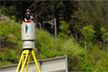
The 3D Terrestrial Laser Scanner (TLS) provide high speed, non-contact data acquisition of large landscape areas with very high accuracy over a long distance (1.5km). Through the combination of LiDAR point clouds and high resolution photos virtual representations of the landscape with a high degree or realism can be produced. This data acquisition technique allows for the transformation of landscape characteristics such as terrain, vegetation and building structures into precise 3d (terrain) models and 3d objects, if necessary with millimeter accuracy. Through an online live-link to the SwissTopo GPS-/GNSS service and a Differential GPS (DGPS) system, each single point of the have exact coordinates. The laser data are used for enhancing environmental analysis and models as well as to improve the visual (it looks like) as well as the functional (it acts like) level of detail of 3D landscape visualizations.

Unmanned Aerial Vehicle
The Unmanned Aerial Vehicle (UAV) allows the Landscape Visualization and Modelling Lab new innovated steps to independence, actuality and accuracy. The data acquisition of landscape and urban systems is now supported through a large area covering system. This easy-to-use autopilot drone is GPS linked and starts, lands and flies autonomy. While the measures TLS at ground, the UAV is scanning the investigation area with taking high resolution pictures from above. Fast automatic post processes allow the generation - next to impressive insights - of actual geo-referenced aerial images, digital surface models and also GIS data with centimeter accuracy over more than 1km² within 30 minutes. Through this air support we can fill the gaps of ground measurement techniques and reach a new quality of data for visualization and modeling.
Landscape Visualization Theatre
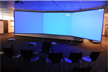
The Landscape Visualization Theatre (LVT) is a full mobile panoramic screen kit with a universal and great impressive attribute. A wide field of view encourages the immersive perception of the participants. With a large screen of 6.30 x 2.10 meters the LVT supports participated planning e.g. in stakeholder workshops by showing landscape visualizations in a realistic view. Furthermore the modern setup supports also 3D technologies for interactive real-time visualizations by what a widely spread application is possible and attract public attention everywhere the LVT is running. The complete boxed transportable set including all hardware and have less than 0.25m³ volume by a weight of approximately 40 kilograms.
CNC-Milling
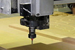
Physical models support iterative design and analysis processes. With a high-speed computerized numerical controlled (CNC) milling station, the lab has the opportunities to create exact detailed models as discussion bases or for real physical process analysis out of virtuality. So the power of these models is the fast transformation from reality to different sets for overlaying or pre-preparation which could shows also different scenarios or designs for a simple understanding.
Lab (Cloud GIS Computing / Render Farm)
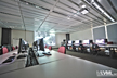
The heart of the LVML is the lab itself. It exists of 17 high-end machines with additional servers with model libraries and storage in background which allow high detailed renderings over large landscape areas within a short time. The performance of this network cloud is also essential for accurate and detailed GIS analysis in big scales. Next to visualization, modeling and analysis workflows, the lab computers are used for education and training. The students have the possibility to work with state-of-the-art techniques in the LVML courses, in which they learn to apply modern tools for planning cases.